Module: Robert Curzon
IntroductionReadExercisesWorks CitedLibrary
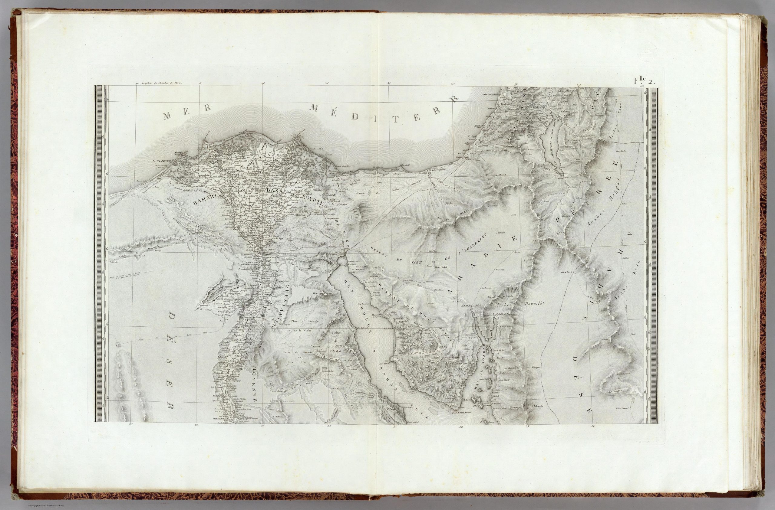
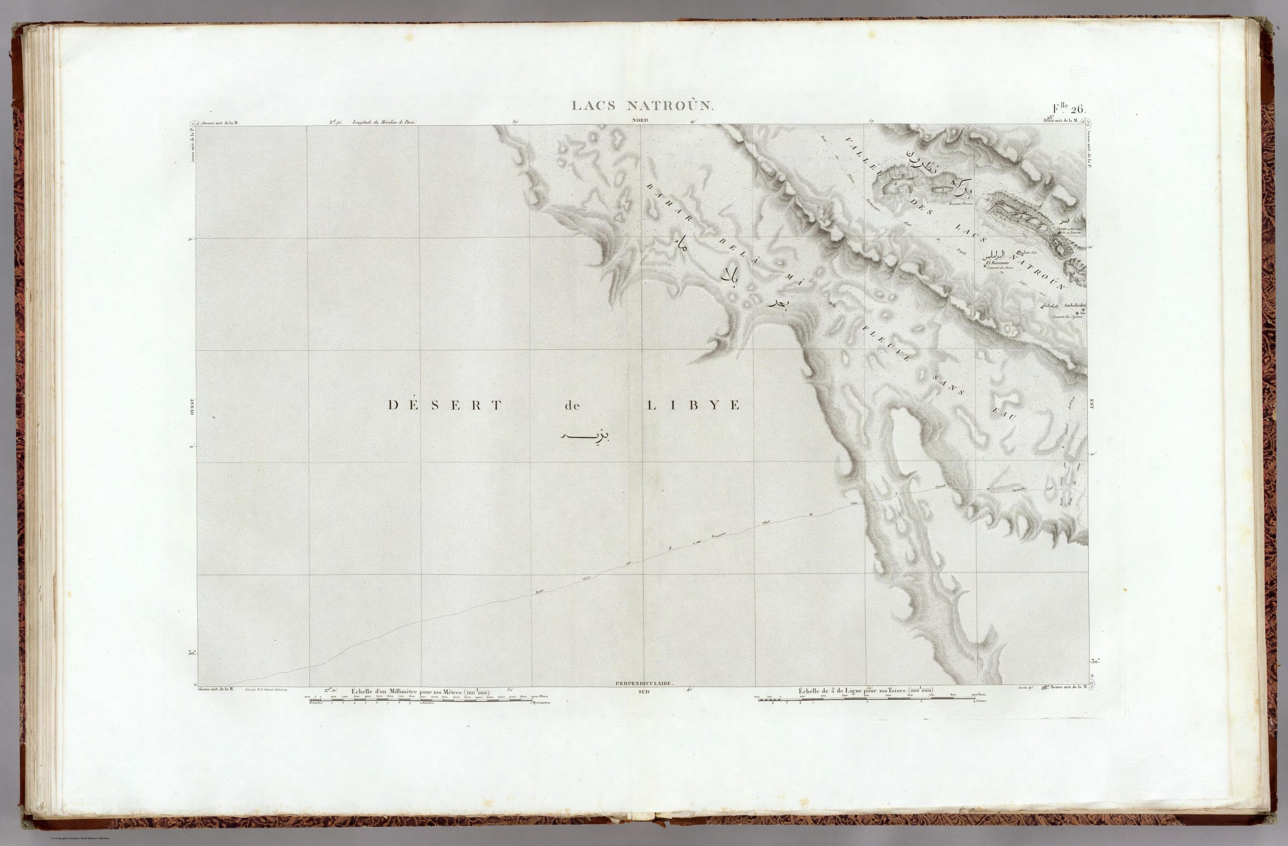
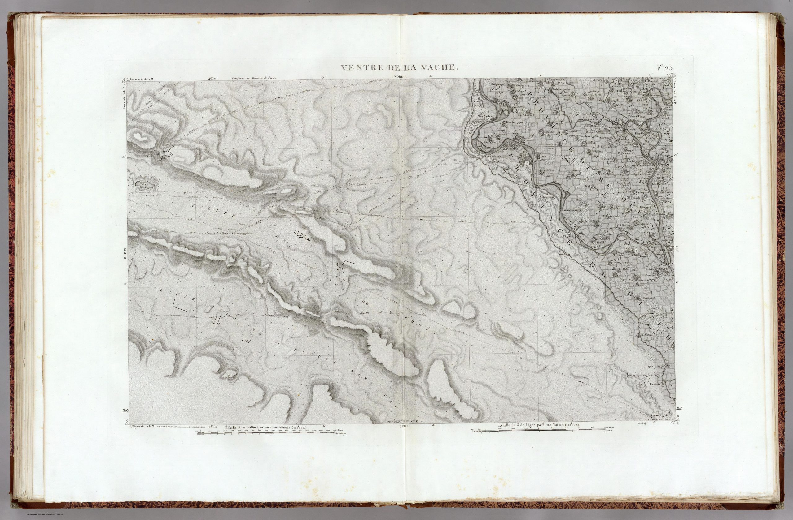
These maps were made in 1818 on the basis of French army surveying under the direction of Pierre Jacotin (1765-1827) during Napoleon’s campaign in Egypt in 1799. They show the Nitrian Desert (“Vallée de Lacs de Natroûn”) with its monasteries at Scetis (Wadi al-Natrūn) and neighboring sites, where Curzon and other manuscript hunters were active in the following decades.
The short description of the Syrian monastery (Dayr al-Suryān) in Meinardus (2016), 166-168 (see course folder).
Add comments to the above maps locating places Curzon mentions visiting in his Monasteries. Include in your comment how Curzon identifies the place (name or description).
2336801
{2336801:DTBFLFPP},{2336801:35ZZ84WI},{2336801:QHP2GAQE}
1
chicago-fullnote-bibliography
50
creator
asc
1
1
672
https://www.manuscripthunters.gwi.uni-muenchen.de/wp-content/plugins/zotpress/
%7B%22status%22%3A%22success%22%2C%22updateneeded%22%3Afalse%2C%22instance%22%3Afalse%2C%22meta%22%3A%7B%22request_last%22%3A0%2C%22request_next%22%3A0%2C%22used_cache%22%3Atrue%7D%2C%22data%22%3A%5B%7B%22key%22%3A%22DTBFLFPP%22%2C%22library%22%3A%7B%22id%22%3A2336801%7D%2C%22meta%22%3A%7B%22creatorSummary%22%3A%22Commission%20des%20sciences%20et%20arts%20d%27Egypte%20and%20Panckoucke%22%2C%22parsedDate%22%3A%221826%22%2C%22numChildren%22%3A0%7D%2C%22bib%22%3A%22%26lt%3Bdiv%20class%3D%26quot%3Bcsl-bib-body%26quot%3B%20style%3D%26quot%3Bline-height%3A%201.35%3B%20padding-left%3A%201em%3B%20text-indent%3A-1em%3B%26quot%3B%26gt%3B%5Cn%20%20%26lt%3Bdiv%20class%3D%26quot%3Bcsl-entry%26quot%3B%26gt%3BCommission%20des%20sciences%20et%20arts%20d%26%23x2019%3BEgypte%2C%20and%20C.%20L.%20F.%20Panckoucke.%20%26lt%3Bi%26gt%3BDescription%20de%20l%26%23x2019%3BEgypte%20ou%20recueil%20des%20observations%20et%20des%20recherches%20qui%20ont%20ete%20faites%20en%20Egypte%20pendant%20l%26%23x2019%3BExpedition%20de%20l%26%23x2019%3BArmee%20francaise%26lt%3B%5C%2Fi%26gt%3B.%202nd%20ed.%20Paris%3A%20Alexandre%20Blondeau%20%5C%2F%20Depot%20de%20la%20guerre%2C%201826.%20%26lt%3Ba%20class%3D%26%23039%3Bzp-ItemURL%26%23039%3B%20href%3D%26%23039%3Bhttps%3A%5C%2F%5C%2Fvia.hypothes.is%5C%2Fhttps%3A%5C%2F%5C%2Fia800704.us.archive.org%5C%2F18%5C%2Fitems%5C%2FDescriptiondelE1FranA%5C%2FDescriptiondelE1FranA.pdf%26%23039%3B%26gt%3Bhttps%3A%5C%2F%5C%2Fvia.hypothes.is%5C%2Fhttps%3A%5C%2F%5C%2Fia800704.us.archive.org%5C%2F18%5C%2Fitems%5C%2FDescriptiondelE1FranA%5C%2FDescriptiondelE1FranA.pdf%26lt%3B%5C%2Fa%26gt%3B.%20%26lt%3Ba%20title%3D%26%23039%3BCite%20in%20RIS%20Format%26%23039%3B%20class%3D%26%23039%3Bzp-CiteRIS%26%23039%3B%20data-zp-cite%3D%26%23039%3Bapi_user_id%3D2336801%26amp%3Bitem_key%3DDTBFLFPP%26%23039%3B%20href%3D%26%23039%3Bjavascript%3Avoid%280%29%3B%26%23039%3B%26gt%3BCite%26lt%3B%5C%2Fa%26gt%3B%20%26lt%3B%5C%2Fdiv%26gt%3B%5Cn%26lt%3B%5C%2Fdiv%26gt%3B%22%2C%22data%22%3A%7B%22itemType%22%3A%22book%22%2C%22title%22%3A%22Description%20de%20l%27Egypte%20ou%20recueil%20des%20observations%20et%20des%20recherches%20qui%20ont%20ete%20faites%20en%20Egypte%20pendant%20l%27Expedition%20de%20l%27Armee%20francaise%22%2C%22creators%22%3A%5B%7B%22creatorType%22%3A%22author%22%2C%22firstName%22%3A%22%22%2C%22lastName%22%3A%22Commission%20des%20sciences%20et%20arts%20d%27Egypte%22%7D%2C%7B%22creatorType%22%3A%22author%22%2C%22firstName%22%3A%22C.%20L.%20F.%22%2C%22lastName%22%3A%22Panckoucke%22%7D%5D%2C%22abstractNote%22%3A%22%22%2C%22date%22%3A%221826%22%2C%22originalDate%22%3A%22%22%2C%22originalPublisher%22%3A%22%22%2C%22originalPlace%22%3A%22%22%2C%22format%22%3A%22%22%2C%22ISBN%22%3A%22%22%2C%22DOI%22%3A%22%22%2C%22citationKey%22%3A%22commissiondessciencesetartsdegypteDescriptionEgypteOu1826%22%2C%22url%22%3A%22https%3A%5C%2F%5C%2Fvia.hypothes.is%5C%2Fhttps%3A%5C%2F%5C%2Fia800704.us.archive.org%5C%2F18%5C%2Fitems%5C%2FDescriptiondelE1FranA%5C%2FDescriptiondelE1FranA.pdf%22%2C%22ISSN%22%3A%22%22%2C%22language%22%3A%22fr%22%2C%22collections%22%3A%5B%5D%2C%22dateModified%22%3A%222026-02-17T10%3A28%3A48Z%22%7D%7D%2C%7B%22key%22%3A%2235ZZ84WI%22%2C%22library%22%3A%7B%22id%22%3A2336801%7D%2C%22meta%22%3A%7B%22creatorSummary%22%3A%22Curzon%22%2C%22parsedDate%22%3A%221849%22%2C%22numChildren%22%3A0%7D%2C%22bib%22%3A%22%26lt%3Bdiv%20class%3D%26quot%3Bcsl-bib-body%26quot%3B%20style%3D%26quot%3Bline-height%3A%201.35%3B%20padding-left%3A%201em%3B%20text-indent%3A-1em%3B%26quot%3B%26gt%3B%5Cn%20%20%26lt%3Bdiv%20class%3D%26quot%3Bcsl-entry%26quot%3B%26gt%3BCurzon%2C%20Robert.%20%26lt%3Bi%26gt%3BVisits%20to%20Monasteries%20in%20the%20Levant%26lt%3B%5C%2Fi%26gt%3B.%20London%3A%20John%20Murray%2C%201849.%20%26lt%3Ba%20class%3D%26%23039%3Bzp-ItemURL%26%23039%3B%20href%3D%26%23039%3Bhttps%3A%5C%2F%5C%2Fvia.hypothes.is%5C%2Fhttps%3A%5C%2F%5C%2Fia800908.us.archive.org%5C%2F4%5C%2Fitems%5C%2F32882019065096-avisittomonaste%5C%2FHighRes_32882019065096.pdf%26%23039%3B%26gt%3Bhttps%3A%5C%2F%5C%2Fvia.hypothes.is%5C%2Fhttps%3A%5C%2F%5C%2Fia800908.us.archive.org%5C%2F4%5C%2Fitems%5C%2F32882019065096-avisittomonaste%5C%2FHighRes_32882019065096.pdf%26lt%3B%5C%2Fa%26gt%3B.%20%26lt%3Ba%20title%3D%26%23039%3BCite%20in%20RIS%20Format%26%23039%3B%20class%3D%26%23039%3Bzp-CiteRIS%26%23039%3B%20data-zp-cite%3D%26%23039%3Bapi_user_id%3D2336801%26amp%3Bitem_key%3D35ZZ84WI%26%23039%3B%20href%3D%26%23039%3Bjavascript%3Avoid%280%29%3B%26%23039%3B%26gt%3BCite%26lt%3B%5C%2Fa%26gt%3B%20%26lt%3B%5C%2Fdiv%26gt%3B%5Cn%26lt%3B%5C%2Fdiv%26gt%3B%22%2C%22data%22%3A%7B%22itemType%22%3A%22book%22%2C%22title%22%3A%22Visits%20to%20Monasteries%20in%20the%20Levant%22%2C%22creators%22%3A%5B%7B%22creatorType%22%3A%22author%22%2C%22firstName%22%3A%22Robert%22%2C%22lastName%22%3A%22Curzon%22%7D%5D%2C%22abstractNote%22%3A%22%22%2C%22date%22%3A%221849%22%2C%22originalDate%22%3A%22%22%2C%22originalPublisher%22%3A%22%22%2C%22originalPlace%22%3A%22%22%2C%22format%22%3A%22%22%2C%22ISBN%22%3A%22%22%2C%22DOI%22%3A%22%22%2C%22citationKey%22%3A%22curzonVisitsMonasteriesLevant1849%22%2C%22url%22%3A%22https%3A%5C%2F%5C%2Fvia.hypothes.is%5C%2Fhttps%3A%5C%2F%5C%2Fia800908.us.archive.org%5C%2F4%5C%2Fitems%5C%2F32882019065096-avisittomonaste%5C%2FHighRes_32882019065096.pdf%22%2C%22ISSN%22%3A%22%22%2C%22language%22%3A%22en%22%2C%22collections%22%3A%5B%5D%2C%22dateModified%22%3A%222026-02-17T10%3A28%3A48Z%22%7D%7D%2C%7B%22key%22%3A%22QHP2GAQE%22%2C%22library%22%3A%7B%22id%22%3A2336801%7D%2C%22meta%22%3A%7B%22creatorSummary%22%3A%22Meinardus%22%2C%22parsedDate%22%3A%222016%22%2C%22numChildren%22%3A0%7D%2C%22bib%22%3A%22%26lt%3Bdiv%20class%3D%26quot%3Bcsl-bib-body%26quot%3B%20style%3D%26quot%3Bline-height%3A%201.35%3B%20padding-left%3A%201em%3B%20text-indent%3A-1em%3B%26quot%3B%26gt%3B%5Cn%20%20%26lt%3Bdiv%20class%3D%26quot%3Bcsl-entry%26quot%3B%26gt%3BMeinardus%2C%20Otto%20F.%20A.%20%26lt%3Bi%26gt%3BTwo%20Thousand%20Years%20of%20Coptic%20Christianity%26lt%3B%5C%2Fi%26gt%3B.%20Cairo%3A%20American%20University%20in%20Cairo%20Press%2C%202016.%20%26lt%3Ba%20title%3D%26%23039%3BCite%20in%20RIS%20Format%26%23039%3B%20class%3D%26%23039%3Bzp-CiteRIS%26%23039%3B%20data-zp-cite%3D%26%23039%3Bapi_user_id%3D2336801%26amp%3Bitem_key%3DQHP2GAQE%26%23039%3B%20href%3D%26%23039%3Bjavascript%3Avoid%280%29%3B%26%23039%3B%26gt%3BCite%26lt%3B%5C%2Fa%26gt%3B%20%26lt%3B%5C%2Fdiv%26gt%3B%5Cn%26lt%3B%5C%2Fdiv%26gt%3B%22%2C%22data%22%3A%7B%22itemType%22%3A%22book%22%2C%22title%22%3A%22Two%20Thousand%20Years%20of%20Coptic%20Christianity%22%2C%22creators%22%3A%5B%7B%22creatorType%22%3A%22author%22%2C%22firstName%22%3A%22Otto%20F.%20A.%22%2C%22lastName%22%3A%22Meinardus%22%7D%5D%2C%22abstractNote%22%3A%22%22%2C%22date%22%3A%222016%22%2C%22originalDate%22%3A%22%22%2C%22originalPublisher%22%3A%22%22%2C%22originalPlace%22%3A%22%22%2C%22format%22%3A%22%22%2C%22ISBN%22%3A%22%22%2C%22DOI%22%3A%22%22%2C%22citationKey%22%3A%22meinardusTwoThousandYears2016%22%2C%22url%22%3A%22%22%2C%22ISSN%22%3A%22%22%2C%22language%22%3A%22en%22%2C%22collections%22%3A%5B%5D%2C%22dateModified%22%3A%222026-02-17T10%3A28%3A48Z%22%7D%7D%5D%7D
Commission des sciences et arts d’Egypte, and C. L. F. Panckoucke. Description de l’Egypte ou recueil des observations et des recherches qui ont ete faites en Egypte pendant l’Expedition de l’Armee francaise. 2nd ed. Paris: Alexandre Blondeau / Depot de la guerre, 1826. https://via.hypothes.is/https://ia800704.us.archive.org/18/items/DescriptiondelE1FranA/DescriptiondelE1FranA.pdf. Cite
Curzon, Robert. Visits to Monasteries in the Levant. London: John Murray, 1849. https://via.hypothes.is/https://ia800908.us.archive.org/4/items/32882019065096-avisittomonaste/HighRes_32882019065096.pdf. Cite
Meinardus, Otto F. A. Two Thousand Years of Coptic Christianity. Cairo: American University in Cairo Press, 2016. Cite
Library
Please login to see these files.